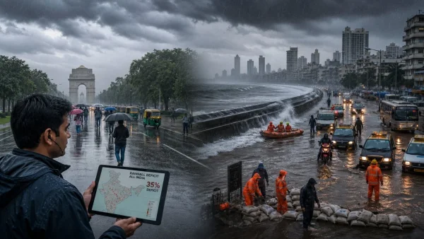
You could say the monsoon has lost some of its steam even as pre-monsoon rain picks up in the north and east, and we’re seeing new cautions for it. A yellow alert is in effect for 23 of Rajasthan’s districts, and 26 in Bihar are being kept under a storm watch. For all the odd bit of relief, normal rainfall has only been in 103 districts to date.
Monsoon stalls, heat lingers
It was a fast start: the southwest monsoon made its way from Kerala to 19 states in 13 days after arriving on June 4. But the pace has died down. It’s been at a standstill over Bhadrachalam in Telangana for a week now, which has put off any rain in Chhattisgarh, Maharashtra and Madhya Pradesh.
Skymet Weather has the monsoon pegged as having been tied up on the west coast for a while, and don’t be surprised if it’s over a week before it gets to Mumbai. They put the lull down to a weak low-pressure zone in the Bay of Bengal.
The numbers tell the story. Out of 723 districts, just 103 have had their fair share of rain. You can see the contrast in the weather: you’ve got your heatwaves and then some thundershowers here and there.
Rajasthan and Bihar under alerts
Things are heating up in northwest India. The IMD has put out a yellow for 23 districts in Rajasthan – Jaipur, Bharatpur, Kota among them – for some thunder and rain. Some 10 districts, Jhunjhunu for one, have already put down as much as 2 inches in a day.
Bihar is in a similar boat, but with more of a stormy edge to it. We have a rain warning for 26 of its districts, like Bhagalpur and Purnia. And yet the heat is still a factor; on Tuesday, 7 of them, Patna included, were over 40 C.
Madhya Pradesh is in for some of that too, with eight of its districts, Raisen and Gwalior for instance, due for thunder and rain. Down in Delhi-NCR, a pre-monsoon downpour on Tuesday with some wind made for the coolest we’ve seen in June, 6 C under what’s usual.
This is what the official word is today:
– Rajasthan: 23 districts on a yellow (Jaipur, Bharatpur, Kota)
– Bihar: 26 districts with a rain warning (Bhagalpur, Purnia, Champaran)
– Madhya Pradesh: expect some in the way of thunder in eight of them, Raisen, Chhindwara, Gwalior
– Haryana: 17 districts including Sirsa and Hisar are on a yellow
– Punjab: 16 districts; some 50 kph winds in the offing
– Uttarakhand: five of the hill districts will likely see some rain
What IMD projects next 4-5 days
The Department of Meteorology is of the view that as the jet stream eases up, the monsoon will pick up some force. You could see the monsoon make headway into Maharashtra, Karnataka, Chhattisgarh and some other regions in the coming 4-5 days as conditions turn in its favour.
It all comes down to the jet streams – those very fast winds up in the upper atmosphere, some 8 to 15 km off the ground. They are what put the weather systems in motion and have a hand in the way the monsoon and Western Disturbances behave.
North and East: a tale of two weathers
Monday was a hot one for millions. In cities across Rajasthan, Gujarat, Maharashtra, Chhattisgarh, Odisha, Bihar, Jharkhand, UP, Telangana and MP, the thermometer went over 40 C. Varanasi was the hottest spot in the country at 43 C.
Then there were the hard numbers from the rest of the country: 42.6 C in Banda and Prayagraj (UP), 42.2 C in Khajuraho (MP) and Brahmapuri (MH), and 42.6 C in Boudh (Odisha). All this while Delhi-NCR was being put in its place by some thunder.
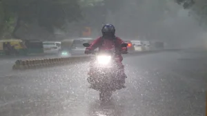
And it wasn’t just the heat. Some localised rain made for a few hiccups. Women in Hansi, Haryana, had to put up with knee-deep water on their way for a Kalash Yatra. Over in Punjab, you had rain in Pathankot and a lot of wind in Jalandhar.
Why the lull is an issue
With the monsoon holding back, you have to deal with water scarcity and heat in a number of states. The rains don’t come in, so the cooling doesn’t either and you’re left with high demand for power and water. You get the odd storm here and there, but no real respite.
What to expect in the way of rain
The IMD is calling for some in the next 48 hours in Bihar, Jharkhand, Odisha, West Bengal and Sikkim; in parts of Bihar, you might be in for 50-70kmph winds. We may also see some heavy going in Assam, Meghalaya, Arunachal, Tamil Nadu, Puducherry and bits of Karnataka.
Rajasthan, MP, Chhattisgarh and Vidarbha are in for some thundershowers, with 40-60kmph winds in the mix. Sikkim, North Bengal, Assam and Meghalaya should be drenched, and the showers will keep up in the south and in Maharashtra.
Come June 18 and 19, the eastern and north-eastern belts – think Bihar, Jharkhand, Odisha, Assam and West Bengal – are set for some heavy rain and 50 to 70 kilometre an hour gusts. It’s good for the heat, but you have to watch out for some localised flooding.
Haryana is under a yellow alert in 17 districts like Sirsa and Hisar as an active Western Disturbance brings some early monsoon feel. In Uttarakhand, expect some light to moderate rain with a bit of thunder in places like Uttarkashi and Pithoragarh.
Punjab has put out a rain-storm warning for 16 of its districts, from Amritsar to Kapurthala, with 50 kph winds. These will do some temporary damage to the temperatures.
The bottom line: the monsoon is stalling and the alerts are piling up. If the jet stream does what it’s supposed to, we’ll see some movement in the next few days in the west and central states. For now, it’s a mix of heat, wind and the occasional storm.