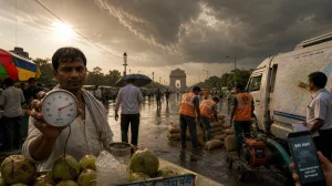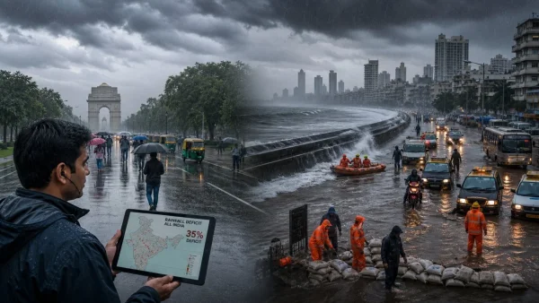
On July 2, 2026, Delhi was at last given some monsoon to cool off from the heat, after three years of June come-ups. Over in Mumbai, they have been put through their paces by some heavy downpours; Juhu put in 205 mm in a day. But you can’t let the fact that the monsoon is everywhere fool you: the national deficit is still 35% and climbing.
Delhi and Mumbai see a sharp turn in weather
The IMD put it in writing: the Southwest monsoon made it to Delhi on July 2, a week or so behind the usual June 27 date. The capital hasn’t had a July start like this since 2021.
A bit of light to moderate rain has brought the temperature down. We’re looking at a low of 22.8 C, some 5.1 degrees under the norm, with a high in the 33s. As of 9 in the morning, the air quality was fine, at 100 on the index.
For the next few days in Delhi, the IMD is calling for overcast skies with some thunder and rain. You can expect some of that on Friday, Saturday and Sunday, from the 3rd to the 5th.
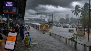
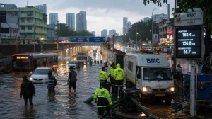
In Mumbai, there was heavy rain and water in the streets as the weather office put out a heads-up. A Red Nowcast Warning went out at 7:45 a.m. on July 2 for Mumbai, Raigad, Palghar and Thane.
They were warning of some hard rain in spots for the next three hours and telling people to be on their guard. The advice was to stay off the low-lying and flooded bits, and to keep clear of any rickety structures, poles and wires. Keep an eye on the official line for updates.
Rain deficit persists despite nationwide onset
Just because the monsoon is in place doesn’t mean the numbers are where they should be. From June 4 to July 2, India got 111.8 mm of rain to the normal 172.4 mm, says the IMD. That’s a 35% gap.
It’s a matter of how you look at it. When you declare an onset, you are noting the conditions are right for the season to move in, not vouching for a deluge.
What IMD data shows and why it matters
We’ve had one of the more sluggish advances in a while, with the monsoon stalling for two weeks in June after an early show in Kerala. When it did get going again, the rain was in patches.
Even as the front moved up, central, western and peninsular India had long dry periods. A lot of districts didn’t get enough during sowing time for it.
You look at the states and it’s a mixed bag. There is a deficit in good chunks of Madhya Pradesh, Maharashtra, UP, Bihar, Jharkhand, Odisha, Telangana, Karnataka, Tamil Nadu and Kerala.
Gujarat and Meghalaya are in the large-deficit camp, 60 to 99% short of what is typical. Then you have Rajasthan, Punjab, Haryana, J&K, Himachal and West Bengal, which are about where they should be.
Ladakh, Sikkim and the Andamans and Nicobars have had more than their share. It is a reminder that the monsoon’s progress can hide what is going on in your own backyard.
If you ask the meteorologists, it’s the El Nino in the equatorial Pacific. It has a way of sapping the monsoon and keeping the low-pressure systems from forming in the Bay of Bengal, which is where you need them for the heartland of India.
With the rain being late and fitful, kharif work has been put under a strain. The Centre has told the ministries to have a plan B. The coming weeks will tell us if the monsoon bounces back and how much trouble we are in for agri and hydropower.
City impacts and civic action
Mumbai’s figures for the last 24 hours don’t lie. In the 24 hours to 8:30 a.m. on July 2, Juhu Airport had 205 mm, Santacruz 204.6 and Vikhroli 192.5. A number of other places were over 150.
That has meant traffic is at a standstill in parts of Dadar, Parel, Hindmata, Charkop, Worli, Goregaon and Andheri. It was a slow start for some rail commuters this morning, with local trains in the 10- to 15-minute red. A Central Railway put it down to the 180 mm of rain the network has had in as many hours, but they say there’s been no serious waterlogging on the tracks. All four lines are running, even if you have to be patient.
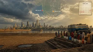
The tides are also in play. The BMC is calling for a 4.27-metre high at 1:45 p.m. on July 2, and 3.71 m later at 1:31 a.m. on the 3rd. You can expect low tide to come in at 7:49 p.m. Thursday and 7:11 a.m. Friday.
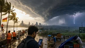
Civic authorities have put out a word of caution for Mumbai and the suburbs: we’re in for some very heavy rain, with the chance of it being extreme on Thursday night into Friday. And don’t be surprised by some 50-60 kmph gusts now and then.
If you look at the numbers from the past 24 hours up to 8 a.m. on the 2nd, the city as a whole has seen 172 mm. It’s a bit more in the east (189 mm) and a little less in the west (165 mm).
Out in Jammu and Kashmir, the rain isn’t letting up in Bhalesa. Doda district officials are on alert for landslides and blocked roads.
Over in Thane, things are a bit more sensitive after a tree came down on a school bus in Mumbai and killed someone. On July 1, Mayor Sharmila Pimpalolkar called for an inventory of any trees that could be a problem, with an eye on places like schools and hospitals. “We want to make sure what we pruned is still sound,” she said, and has told her departments to be in step with one another. If you spot a hazard, the TMC wants to hear about it.
Delhi is under a blanket of clouds with some moderate rain from the IMD. The odd shower has been a welcome break from the stickiness as people get ready for a wet weekend.
What to watch in the next 72 hours
The IMD is forecasting the kind of hard rain that can make waterlogging worse when you factor in the tides. Haryana, Punjab and bits of Rajasthan and M.P. are in for their monsoon from July 2, which should help make up some ground if the bands hold.
For those in the thick of it, here is what the authorities are saying:
– Stay off the low-lying or flooded spots
– Give damaged structures a wide berth
– Don’t stand near poles or wires
– Keep an ear to the ground for IMD and civic updates
Some figures to keep in mind:
– We’re at 111.8 mm nationally, well short of the 172.4 mm mark
– That’s a 35% deficit as of July 2
– Delhi is five days behind schedule
– In Mumbai, Juhu has 205 mm; Santacruz 204.6 and Vikhroli 192.5 in a day
– 50-60 kmph winds are in the cards
City planners will be on top of the tide times. When the 1:45 p.m. high on the 2nd hits, drainage in some seafront areas may not be as quick as you’d like, particularly if the rain comes on strong.
Inland, it all comes down to how fast low-pressure builds over the Bay of Bengal. More of it means moisture for the kharif crop and fuller reservoirs. For the farmer, this is the make-or-break period. Close the gap and you don’t have to plan for the worst; leave it open and you’re looking at delayed sowing and more reliance on irrigation.
Power companies are watching the hydro side of things too. Reservoir levels have a lot to do with supply and cost when demand is at its peak.
So the question for July is whether we can make up for June. The IMD is sounding the alarm on the western coast, but it’s what happens inland that will tell the tale. With Delhi in a new rhythm and Mumbai in for some rough weather, the monsoon has two sides right now: the day-to-day in the cities and the national shortfall. The next few weeks will tell us if we’re going to see the totals India is after.