
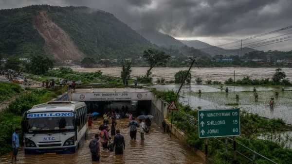
In short, a new wave of monsoon is coming to test the region. The IMD is talking of showers that run from heavy to very heavy, enough to cause disruption. For now, Meghalaya is the most exposed, but one can see Bihar and West Bengal preparing for it as well.
East and Northeast brace for deluge
An alert for heavy to very heavy rain is in place for the next few days across the Northeast, as well as in Bihar and bits of West Bengal. If you are a commuter in Bengal or Bihar, plan for water on the roads and underpasses that may be shut. A look at the traffic reports before heading out is in order.
July 13 should bring extremely heavy rain to Meghalaya, as well as to Sub-Himalayan West Bengal and Sikkim. The rest of the week will see widespread rain in Arunachal Pradesh, Assam, Meghalaya, Nagaland, Manipur, Mizoram and Tripura, per the IMD.
Already-soaked ground raises flood and landslide risk
Mawkyrwat in Meghalaya put down 25 cm in a day, which is a case in point for how fast a slope can give way when the earth is full of water. By the book, the IMD calls 7 to 11 cm in 24 hours “heavy”, 12 to 20 “very heavy” and anything over 21 “extremely heavy”.
It is not just the hills. In the 24-hour period, Bansgaon in Gorakhpur, East UP, had 17 cm. The weather office says Siwan in Bihar was at 8 cm and Pundibari in the Sub-Himalayan part of West Bengal at 9 cm.
Parts of Assam and Meghalaya – the Garo, Khasi and Jaintia Hills and Cachar among them – are under a low to moderate flash flood watch until about midday on the 13th. As for landslides and mudslides, they are a possibility in Meghalaya, Assam, Arunachal, and in the hilly tracts of West Bengal and Sikkim.
Wind threat to travel and power lines
Bengal and Bihar can count on thunderstorms with 40-50 kmph winds, with gusts to 60, for the week. The IMD also has 40-50 kmph in the forecast for some spots in Jammu and Kashmir, Madhya Pradesh, Chhattisgarh, Odisha, Andhra, Karnataka, the Andaman and Nicobar and others on various days, with the odd 60 kmph gust.
What to expect between July 13 and July 19
Bihar is where the heaviest multi-day rain is headed. After the very heavy kind on the 13th and 14th, there is a forecast for more of it through the 19th. In Gangetic West Bengal, it should be heavy until the 17th. Odisha’s pattern is a bit up and down.
For its part, Odisha is in for some very heavy rain on the 14th and 15th, with heavy rain on the 13th and 16th. The IMD has put out a word of caution for East Uttar Pradesh, where some isolated heavy rain is in the offing for the next four or five days.
For the rest of the region, here is what to be on the lookout for:
– In Meghalaya and the Sub-Himalayan tracts of West Bengal and Sikkim, conditions are set to be extremely heavy on July 13.
– Bihar can expect very heavy downpours on the 13th and 14th, with more to come between the 15th and 19th.
– Heavy rain is the forecast for Gangetic West Bengal through July 17.
– Odisha will see a mix: very heavy on the 14th and 15th, and heavy on the 13th and 16th.
Elsewhere, the monsoon takes a back seat to heat and lulls
It is a different story in northwest, west-central and south Peninsular India. For the coming week or so, the IMD is calling for subdued rainfall. At most, there will be some scattered showers in places like Punjab, Haryana, Delhi, West UP, Gujarat, parts of Maharashtra, as well as Telangana, Tamil Nadu, Karnataka and Kerala.
There may be a brief upturn in Konkan, Goa and the coasts of Karnataka and Kerala as the period winds down. But for the most part, any heavy weather in the northwest is not due until the 17th to 19th, when Himachal, Uttarakhand, J&K and some of UP could get in the way of some isolated heavy showers.
In the capital, it is going to be a hot one. The IMD has partly cloudy skies in store for Delhi-NCR from the 13th to the 16th, with no real rain. Temperatures should top out at 36C to 39C and bottom at 26C to 29C, with surface winds of 20-30 kmph, and the odd gust to 40.
Even as the monsoon rages in other corners, some of Coastal Andhra and Yanam are likely to be in a heatwave from the 13th to 15th. The same goes for much of Odisha, Rayalaseema, Tamil Nadu and the Union Territories of Puducherry and Karaikal, which will be hot and muggy.
A note to farmers, those on the road and fishermen
Those in Assam, Bengal, Bihar and East UP have been told to make sure their rice, maize, jute and vegetable fields are well-drained to save the crops. In the cities, it is best to allow for a longer commute; waterlogging and underpass closures are a given during the heaviest of the bursts.
Some simple measures are being recommended:
– Have a look at traffic before you head out
– Give waterlogged underpasses a wide berth
– See to the drainage in the fields
– For the fishing community, stay away from the rougher waters
Fishermen are being advised to hold off on putting to sea in the Arabian Sea and Bay of Bengal for the time being. Strong winds and churning seas are expected in the waters off Gujarat, Odisha, West Bengal, Andhra, Sri Lanka, even as far as Somalia and Oman.
What is behind it all
The IMD says an active monsoon trough is channeling moisture to the east, with its end a bit to the north of where it usually is. Add in some cyclonic activity in the North Bay of Bengal and Bangladesh, plus a trough running from northwest Bihar to Manipur, and the rain bands are only going to be reinforced.
Then there is a Western Disturbance over central Pakistan. All in all, these factors are keeping the rain focused on the east and northeast, while the west and peninsula have to make do with little in the way of monsoon this week.