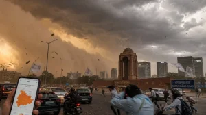
The systems that will bring rain have finally started moving toward north India, after the endless heat. Several Western Disturbances will cause dust storms, thunderstorms and rain in the next few days and could lower temperatures to below 42C from April 29, as the latest weather reports show. The India Meteorological Department (IMD) is watching these changes closely.
A Western Disturbance is a weather pattern that develops over the Mediterranean Sea and travels east, bringing with it moisture and unstable weather. During the hottest part of the summer, these are about the only thing that can stop a long period of very hot temperatures across North India.
Timeline and forecast details
Meteorologists say we could see some dust storms and light rain as early as the evening of April 27. The weather will get busier between April 28 and April 30, with widespread dust storms and thunderstorms across Delhi, Punjab, Haryana and sections of Rajasthan.
The forecast is that temperatures will probably start to fall to under 42C from April 29. It won’t end the summer heat, but even a small decrease in temperature will be a big help. How much cooler it gets will depend on how strong and how often the thunderstorms are.
Forecasters highlight the key developments to watch:
– Isolated dust storms and light rain from April 27 evening
– Stronger dust storms and thunderstorms between April 28 and April 30
– Affected states include Delhi, Punjab, Haryana, and parts of Rajasthan
– Temperatures could dip below 42C from April 29
– Cooling depends on thundershower intensity and frequency
– Localised disruptions possible due to strong winds
Heatwave context and significance
North India has been extremely hot for days, with temperatures reaching very high levels. After being in this heat for so long, people now have a real chance of getting cooler.
Weather forecasters are calling the approaching disturbances the “only hope” for escaping this hot period. It is not very common to have Western Disturbances following each other so quickly during a time of such intense heat, and the IMD is paying close attention to the situation.
Expected impacts on ground
Dust storms, which often happen before these kinds of weather changes, are caused by strong, sudden gusts of wind that pick up dirt and reduce how far you can see. They are usually followed quickly by rain and a fall in temperature, and can completely change the conditions in an area in a short amount of time.
Meteorologists warn that although the rain will make the heat less stressful, the storms that come with it could cause problems in certain areas. These could include not being able to see very far, delays to journeys and the possibility of winds causing damage. Those in authority are looking at the situation as the systems get closer.
What to watch next
If the forecast is correct, the next few days could be a turning point, offering a short, but welcome break from the heatwave. Meteorologists are following a Western Disturbance that is coming toward India and are looking for other systems to follow it.
We might see the first effects on the evening of April 27, with a more noticeable period of dust storms and thunderstorms from April 28 to April 30. From April 29, many places are likely to start getting cooler. At the moment, it looks as though these rain-bringing disturbances will bring cooler air and the relief everyone needs.