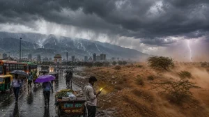
It’s been an early-season stumble for the monsoon. Rainfall is 28% under par countrywide because the clouds just won’t put in a consistent show. The stalling is being put down to an oddity in the upper atmosphere, with a turnaround on the cards post-20 June. For now, you are more likely to see a spotty shower than the kind of drenching rain we are used to in June.
You have to look at it as something of a paradox: the monsoon has made its way into the south and centre of the country, but the rain has not kept up. If you study the maps, you will see vast areas of central, eastern and peninsular India in the lags, with only here and there a report of too much. A few districts in the northwest have had their share of brief localised downpours.
What is holding back the monsoon
The reason for the let-up is a kind of high-altitude tussle over the subcontinent. The westerly jet has gone further south than you would expect, say the experts, and in doing so has put a damper on the easterly jet that is meant to be the engine of the monsoon.
Without that kind of backing, systems coming off the Bay of Bengal can’t make headway inland. They don’t have the flow to push them, so they either die out or stay put in one spot rather than making a run for the interior of the country.
The numbers behind the slowdown
The IMD figures tell the story. In the 10 days from 4 to 14 June, we put down 34.3 mm of rain where 47.7 mm is the norm – a 28% gap. It is an uneven spread; the central, eastern and southern parts are running dry while any excess is in isolated pockets.
This isn’t a lack of moisture, forecasters will tell you, but a matter of the winds not being in the right place. The current set-up is breaking up the normal flow of the monsoon, and you can see it in the dry spells that are more common in the central and eastern states and the peninsula.
Forecasts were caught off guard
The reality is starker than some of the seasonal outlooks led on to believe. Back in May, a number of long-range calls for a good start were made on the strength of the oceans. Then the atmosphere threw up a roadblock no one saw coming.
We are not out of the woods, though. There is still time to make up for it. Some of the models have the easterly jet picking up again after 20 June. Put that in place and the whole system should work better, letting the rain come in as it should.
What to watch in late June
Should the easterly jet hold, the monsoon is expected to reorganise itself. Systems from the Bay will be able to get in deeper, which is what is needed to close the deficit and get things moving in the central and eastern corridors once more.
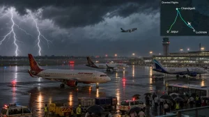
Then there is the view from a weather man in Maharashtra who is seeing some model guidance for some heavy going in and around Mumbai and the rest of the state on about 25-26 June. He is moderately sure of it, and it looks like we may be in for a wetter turn of events.
Here is what the forecasters have on their radar:
– How the easterly jet is performing after 20 June
– Whether the Bay of Bengal systems are making it inland
– Any sign of a rebound in the central and east
– A few localised showers in the northwest as opposed to a full-on spell
The next few weeks will be telling. A move in the upper winds at the right time can put the monsoon back on track, but if this stand-off drags on, the season will be in arrears. We will have to see what the IMD has to say when the dust settles on whether June was any good or not.