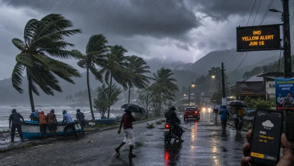
There is a new weather watch for parts of the state on June 16, 2026, with the IMD pointing to heavy rain and gusts. The Yellow Alert for Kottayam and Ernakulam is a heads-up for isolated downpours that could be an issue for anyone in the hills, by the coast, or in transit for the first part of the week.
IMD warning and what it means
For Tuesday, June 16, 2026, the IMD has put Kottayam and Ernakulam on a Yellow Alert. They are talking about up to 115.5mm of rain in a 24-hour window in some spots, which is enough to cause localised flooding and make for difficult travelling in the more exposed areas.
By the book, a heavy rainfall warning from the IMD is when you’re looking at 64.5 to 115.5 millimetres over 24 hours. But even a brief, hard spell can clog up city drains or make for trouble on the high range slopes once they are soaked through.
You might think the southwest monsoon is losing some of its edge in the state, but the IMD is still calling for rain in Kerala for the next five days. Add in some gusty winds on the coast and you have a few risks to be aware of in open areas.
Districts on watch beyond the alert
If you are not in one of the two districts under the alert, there is a possibility of some light to moderate rain in places like Pathanamthitta, Alappuzha, Kottayam, Idukki, Ernakulam and Kasaragod. Thiruvananthapuram, Kollam, Thrissur and Malappuram could see 40 to 50 kmph winds and a little rain as well.
So far, aside from Kottayam and Ernakulam, there are no other special alerts from the authorities. But they say to keep an eye on things; as the system moves in and some cells build up, the picture can change.
Risks for hills, coast and urban pockets
We are telling people in flood and landslide zones to be on their toes. If you are near a river or downstream, don’t go camping by the stream or try to cross where it’s risky – water can come in fast with these kind of downpours.
The IMD is also flagging that the wind can be a problem for anything not sturdily built, and will likely take some branches with it along the coast. In the cities, you may find some waterlogging if the rain comes in at rush hour, so give yourself a little extra time and check in before you head out.
Safety guidance for Monday night and Tuesday
Unless you have to be out, the weather department says to stay in. From 2 to 10 pm, the sky will be overcast and you can have a lot of rain and lightning with very little notice.
It is a good idea to hold off on any travel you can do without and follow the hyperlocal reports. A flexible schedule will save you from a sudden squall, and being a little prepared will make any power or mobility issues easier to handle.
Here is a list of do’s and don’ts from the authorities for when the thunderstorms roll in:
– Stay off open ground and rooftops
– Don’t be standing under a tree
– Give water bodies a wide berth
– No swimming or an outdoor bath
– Put the kites and sports away
– Leave the non-essential work for later
What happens next
The IMD will be on top of this for the next five days. If we see the rain bands move in on the 16th and get heavier near where people live or on the roads, you can expect an update to the warnings.
Do check the forecast now and then to be safe. Should a new warning come out, you may want to curtail your plans for the day, tie down anything that a 40 to 50 kmph wind can pick up, and have your emergency contacts close by.
Why this matters now
Even in a lull of the monsoon, a hard hit of rain in a narrow corridor can be a nuisance. The Yellow Alert for Kottayam and Ernakulam is there to remind us to be careful and be ready for some intense weather on Tuesday.