You can put down a late monsoon for Delhi; the numbers point to early July. The system has been having trouble getting out of central India. There may be a few showers here and there, but don’t be fooled – these aren’t the real thing. It’s going to be a while before you get any real respite from the weather.
Delhi’s wait likely extends into July
Normally, the southwest monsoon is in town by about June 27. We saw it on the 29th last year. Not so this go-around. Navdeep Dahiya, who keeps tabs on the weather, is calling for a longer lag and has put the window for the capital at July 6-10.
It takes 10 to 15 days for the monsoon to make its way from the centre of the country to the north, Dahiya says. If the pace is what it should be, and places like Odisha and Chhattisgarh are done with by month’s end, then early July is where it’s at for us.
The India Meteorological Department is seeing the same thing: a slower than usual advance. They have the monsoon moving into Maharashtra, then on to Rajasthan and Gujarat around the 23rd. You can see the drag in the fact that it has already gone past Mumbai's typical June 8 date.
Why the system stalled
What you have is a kind of tussle between the Arabian Sea and the weather over the Bay of Bengal. Mahesh Palawat from Skymet Weather says that kind of give-and-take is hard to come by this year, which has sapped the monsoon’s momentum heading north.
Even though the south and parts of Maharashtra are under the monsoon’s influence, officials at the IMD will tell you it hasn’t made it to the centre yet. As of Saturday, the trough was running through Harnai, Solapur, Hyderabad, Bhadrachalam, Koraput, Phulbani, Ranchi, Jamui and Muzaffarpur.
Put simply, the monsoon won’t be in any hurry to move until we see something more from the Bay of Bengal. So don’t count on an early push into the north; for Delhi, we’re looking at the first half of July.
Expect heat, humidity and isolated showers
We’ve had our share of rain and thunder of late, but experts are quick to point out those were western disturbances. It’s an important distinction since they don’t do much to put a dent in the overall swelter in the city.
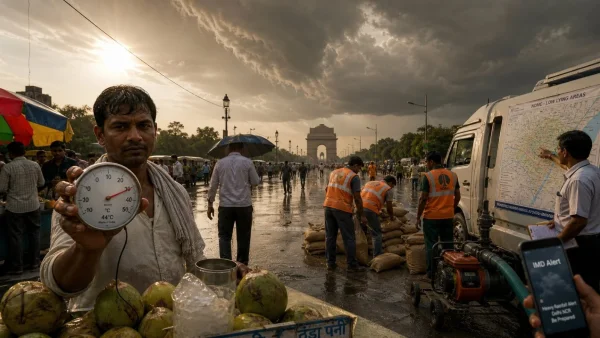
A yellow alert was put out on Saturday and ratcheted up to orange, but not one of the stations in Delhi had any rain to show for it by 5.30pm. It was hot and sticky all day with only the odd bit of activity for relief.
Temperatures on Saturday hit 40.2C, well above the 38.6C you’d expect. The low was 28.7C, right in line with the norm. With the humidity swinging from 35 to 68 per cent, the afternoons were no fun.
If you look at the ‘feels like’ figures, you can see why: 42C at 11.30am, 44.2C by 2.30pm and 43.4C at 5.30pm. The IMD is forecasting some rain for Sunday and Monday to bring the high down to 36-38C, but it will be back up to 38-40C by the 26th.
The numbers don’t lie.
You can expect the high for June 20-24 to be 38.6C, with a small let-up to 37.2C in the days that follow through the 29th. Then there are the northwesterly dry winds that Palawat says will be with us for the next few days, making it all the more of an ordeal.
Deficit is up, but July may make up for it
The numbers on a national level are underwhelming. According to the IMD, we’re looking at a 41.1% monsoon shortfall across the country: 51.5mm has fallen from June 1 to 19, well below the 86.7mm average. In the northwest, the gap is not as wide – 4% to be exact.
In that part of India, 34.9mm was put down between June 1 and 19, versus 36.4mm in a typical year. It’s a milder deficit, but it doesn’t alter the fact that the monsoon is behind schedule.
Look at Delhi and you have a case in point. The city has had 22.7mm of rain this time around (June 1-20) as opposed to 88.01mm last year. The normal for the month is 74.1mm, so the numbers don’t lie.
"Rainfall has been 20 to 30 per cent off the mark,” Dahiya put it. He figures the monsoon will be a bit of a non-event when it does come, but he is open to the possibility that July will even things out.
Then again, a bad June isn’t the end of the world. It usually only accounts for 19 or 20 per cent of the season’s total. But it does put some pressure on July to step up.
What to look for in the coming week:
– Maharashtra should see the monsoon in by the 23rd
– Delhi’s window is likely July 6-10
– Don’t count on any respite from the heat index, even with a passing shower
– Some rain over the weekend might give you a breather
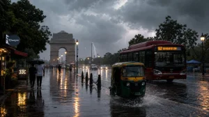
City on alert for waterlogging
With the timetable in flux, the Delhi government is putting its house in order for any flood risk. CM Rekha Gupta has told her departments to be ready for trouble at the usual hotspots and has put a nodal officer in charge of each one.
“Any waterlogging and the officer in charge will answer for it,” she said. “We want our teams on standby for any kind of emergency.”
She has also made sure that rescue gear is in good shape and that there is a plan for evacuations if it comes to it. The idea is to have everything in place while we wait for the monsoon to show up.
What it means for you
For the time being, it’s going to be muggy in the afternoons with some odd thunderheads and no real way to escape the heat. A storm in the evening won’t do much to cool things off without a proper monsoon in force.
There is a lot riding on the next three weeks. If the monsoon makes headway in central India as the signs suggest, we are still on track for a start in early July. The worry is that if it drags on, we’ll see more of a strain on water and the city will be less comfortable. For now, the administration is prepping for floods and the IMD is on top of it, but we are waiting for something from the Bay of Bengal to get the monsoon moving.