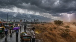
You could say Delhi had a well-earned break from the unrelenting summer. Tuesday was made the coolest of the month by some rain-cooled winds and a few neighbourhoods got in on the action with overcast skies and a shower or two. Temperatures were nowhere near where they should be for this time of year, says the India Meteorological Department (June 16, 2026).
Relief as the heatwave runs out of steam
It was a far cry from the kind of scorching we had earlier in the month. Even in the afternoon, the highs in Delhi-NCR were held down. Take Safdarjung, the city’s base station: 33.3 degrees Celsius, a good 5.5 notches under what you’d expect.
It wasn’t the same everywhere, but the moderation was felt across the board. Ridge was 3.8 notches below normal at 34.5, and Palam was 6.7 notches in the red at 32.5.
The story behind the change
Mahesh Palawat from Skymet Weather puts it down to a cyclonic circulation over Punjab, Haryana and the surrounds that set the stage for some rain in the capital. Add in some moisture from the Arabian Sea on the southwesterly and you have your thundershowers.
With all that moisture in the air, you see the city go from being sweltering to cloud-heavy. It’s a way of keeping the sun in check and letting the wind do its work, so you get a steeper drop in the daytime for mid-June than is typical.
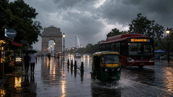
How the rain and heat broke down
The showers didn’t last long, but they made an impression. From 8:30 to 5:30, Palam was the wettest spot with 9.1 mm, per the IMD. Then you have 2.8 mm at Safdarjung, 2.5 at Ayanagar, 1.2 at Lodhi Road and just a trace at Ridge.
If you look at the thermals, they follow the rain. Ayanagar hit 32.7 (5.9 notches low), Lodhi Road 33.2 (5.8 notches low) and Safdarjung’s 33.3 fits right in with the rest of the cooler side of town.
Evenings were milder, too. Ridge went as low as 23.0, 3.8 below normal. Palam was 24.0, also 3.8 under. Safdarjung put in a 25.7 minimum, 1.8 degrees shy of average.
Lodhi and Ayanagar were a bit chiller at 23.6 each – 4.4 and 2.3 notches below normal, to be exact. When you see that kind of uniformity from one station to another, it’s a sign of a moisture build-up in the city.
A short break, then the heat comes back
Don’t count on the overcast to clear up any time soon. The IMD has a cloudy sky with some rain and storms in the cards for Wednesday. You can figure on a high of 34 and a low of 26.
Experts don’t see a sudden spike in the heat with the humidity the way it is. We’re looking at thunderstorms until the 21st, and then a slow climb. Once the clouds part after that, the rise will be more of it.
What to keep in mind for the week:
– Some storm activity is in the offing till June 21
– Highs will be in the vicinity of normal
– Things will warm up from June 21 on
Air quality
The CPCB had the AQI at 116 at 4 pm, which is ‘moderate’. For those who don’t have the chart handy, anything 101 to 200 is moderate. 0-50 is good, 51-100 satisfactory, 201-300 poor, 301-400 very poor and 401-500 is severe.
More than just a one-day thing
The way June goes can be a hint of what the monsoon will be like in north India. What we’ve seen in Delhi is how a bit of moisture and a cyclone can turn the tables on the heat in no time.
For those living here, the takeaway is that the relief is there, but it won’t hold. Humidity is up and we’re told to expect a gradual warming past the 21st, so the window for comfort is closing, even if we aren’t at the top of the thermometer yet.
The bottom line
Palam’s 9.1 mm of rain was enough to make a difference in the daytime. You see it in the numbers: 6.7 notches below normal for a maximum, with Ayanagar, Lodhi and Safdarjung in a like-minded range.
As long as the forecast holds and the clouds are there, you won’t see much of a spike. But when the storms let up, a step up in the temperature is to be expected, in line with what the IMD is saying for after the 21st.