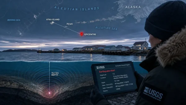
The 9 August 2026 event in Alaska drew focus to the state’s seismic activity and safety protocols. According to the US Geological Survey, the quake put its epicentre 76 kilometres from the community of Atka at 16.7 kilometres down. No word has come in on any losses or harm.
Location and basic parameters
USGS figures put the tremor 76 kilometres southeast of Atka with a recorded depth of 16.7 kilometres, numbers that go some way to defining the nature of the shaking for later review.
With the magnitude confirmed at 5.0, one has the basics of what transpired. That information, along with the location and depth, provides an early picture while officials are on the lookout for anything further.
How the information emerged
The agency put out its update on 9 August 2026. One can see in the coverage an initial posting at 17:00 IST and another at 17:34 IST with the same particulars.
In all of those updates the US Geological Survey was the source for the seismic specifics, right down to the distance from Atka and the depth. Nothing else was added to the advisories.
Initial impact assessment
Early on, the emphasis is on nailing down the epicentre and magnitude before one gets a clear view of conditions on the ground. As of publication, there were no immediate reports of any kind of casualty or damage.
Authorities have not put out any word of structural harm or other losses in the time covered by the updates, which speaks to the preliminary state of the information at hand.
For a quick reference, these are the statements that have been put forward:
– Magnitude of 5.0
– 76 kilometres southeast of Atka for the epicentre
– 16.7 kilometres in depth
– No immediate reports of damage or casualties
What to expect next
Should the situation alter after the first round of advisories, subsequent notices will make that plain. Any communication from the agencies would be to confirm the standing or point to new impacts.
One will look to USGS for the technical side of things. If more is forthcoming, it is likely to restate the location and depth and offer an update on the status of any damage.
Why this update matters now
Getting prompt confirmation from USGS is what allows for a proper response and keeps the focus on what is verifiable. The core facts are in place with a 5.0 magnitude and an epicentre 76 kilometres out and 16.7 kilometres down, even as the situation is tracked.
The timeline at a glance
USGS reported the quake and it was reflected in the agency’s 9 August 2026 updates. Both the 17:00 and 17:34 IST entries carried the same technical data.
There was nothing to suggest a change in those updates. The lack of any report of casualties or damage held true for the duration.
What readers should watch
New advisories would tell if any impacts have come to light since the initial reporting. For the moment the figures stand: 5.0 magnitude, 16.7 kilometres deep, 76 kilometres to the southeast of Atka.
Attributed to the US Geological Survey, those are the most dependable details we have. Anything down the line will be built on them.