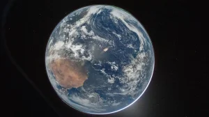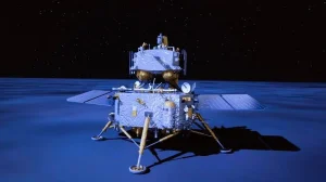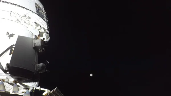
Artemis II wasn’t just a trip around the moon. It used many years of geology lessons in a live science operation, taking pictures of the entire moon from 6,545 kilometers above the surface and recording details of the far side. These pictures weren’t random; the astronauts were specifically trained to think as geologists in the field, and to work as photographers with very little time.
Why rigorous lunar observation training matters
NASA’s intention with Artemis II was to try out the astronauts, equipment, and procedures for the first return to the moon’s surface later in this decade. As one geologist on the NASA science team put it, astronauts’ direct observations are important for filling in gaps between the information from orbiting equipment and what the crews will need to know when they are on the ground.
The Apollo missions orbited at approximately 110 kilometers. Artemis II was at a much higher altitude, allowing it to get a view of the entire moon, both at the poles, and to fit large areas of the landscape in a single picture. The crew’s training helped them decide what was important and then take pictures of it purposefully.
The mission also went farther from Earth than anyone on Apollo 13. Being in that distant part of space tested the cameras and communications, but also the astronauts’ ability to work quickly through a list of pictures they needed to get, and to use their scientific thinking at the same time.
From classroom to crater: the Artemis geology curriculum
The training started with “Lunar Fundamentals,” a week of classroom time dedicated to how the moon formed and what it’s made of. The geologist said they focused on how craters from impacts are made, volcanic activity and the types of rocks that make up the lunar highlands and maria, and this gave the astronauts a common language for science.
The classroom work provided a base of knowledge, but the real learning happened with the field work. NASA sent the crews to places on Earth – in the United States, Canada, and Iceland – that are similar to the moon. These areas have the same kinds of surfaces, structures and lighting issues that astronauts will have to deal with when looking at the moon while under time pressure.
By practicing how to describe what they’s seeing, how to arrange a picture, and how to decide which samples to collect, all on Earth, the team developed the skills they’d need to make clear scientific requests from inside Orion. The geologist stressed that doing field work improves the ability to recognize patterns and to use the radio effectively, both important when every second matters.
Kamestastin Lake: an Earth analog with lunar DNA
A major part of the training took place at Kamestastin Lake in northern Labrador, a crater from a meteor impact on the land of the Mushuau Innu First Nation. About 35 million years ago, an asteroid one or two kilometers across hit ancient rock, and that’s how the crater was made.
The crater contains broken rock and melted rock from the impact that’s similar to materials found on the moon. Importantly, a large portion of the crater is made of anorthosite, which is the same type of rock that forms the lunar highlands. Because of this perfect match, Kamestastin Lake was a great place to practice identifying highland areas from orbit.
Getting things organized was as difficult as the science itself. The team used Twin Otter airplanes to get to the location, set up a camp away from civilization, and used small boats to reach the rocky areas they wanted to study. When working with actual limitations, a geologist pointed out, it’s like flying: you need to plan very carefully, work in the most efficient way possible, and write down everything that happens.
Respecting place: Indigenous knowledge and lunar exploration
The Kamestastin training also emphasized relationships. The team worked very closely with the Mushuau Innu First Nation and from them, learned about the importance of the moon in their history and traditions. Around the campfire, the Innu Guardians told stories about Tshakepesh, a hero whose bravery and determination were relevant to the mission.
And for the geologist, this wasn’t just an addition to the main work; it was a reminder that exploring somewhere is something people do together, and should show respect for both the people who live there and the place itself. That viewpoint went with the team into space, and made them humble and careful as they took pictures of the moon for both science and for the public.
Practicing science in motion: the Science Evaluation Room
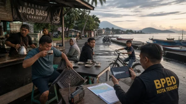
Artemis II wasn’t just a test of the spaceship. It also launched the Science Evaluation Room (SER) at Johnson Space Center. This special center connected the people controlling the flight, the scientists, and a dispersed team of geologists, all under one leader who decided what lunar science was most important during their shift.
Kelsey Young, a science officer, was the main link between Mission Control and the SER. During the quick pass by the moon, her real-time conversations with Canadian astronaut Jeremy Hansen showed a new pattern for doing science in deep space: brief, clear communications that turned all the training into specific instructions for taking photos.
The geologist who helped decide what the people in the SER would do explained why this is important. On a real mission, teams must make quick choices about what is more important. The Artemis II practice run allowed NASA to improve how they choose what to look at, how to quickly look at the pictures, and how the astronauts’ opinions change the next round of pictures taken.
Turning lessons into images: what the crew captured
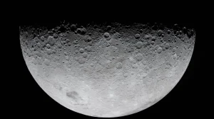
From a great height, the astronauts photographed craters, flat areas of old volcanoes, winding channels, and cracks in the moon’s structure, paying particular attention to differences in color and how things looked. They captured the entire moon’s face, including the poles, which are central to NASA’s plans for landing on the surface. These focused pictures will help make the science of the landing spots more accurate and help assess the light conditions.
During a seven hour stretch on April tth when the moon was between them and the sun, the crew recorded a rare solar eclipse while in space, and later got a clear image of the Milky Way from the Orion constellation. NASA quickly put some initial pictures on X (formerly Twitter), and said there would be more as the team sends down and works with all the images.
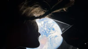
The crew also recorded pictures of the Earth appearing and disappearing over the edge of the moon, and noticed bright flashes probably from meteoroids hitting the lunar surface. These observations, along with accurate times and the path the spacecraft took, will give researchers new methods for studying the moon’s surroundings and what is happening on its surface.
What the data means for Artemis IV and beyond
The pictures and recordings from Artemis II are already going into computer programs for analysis. Scientists are confirming how well astronauts can tell different types of rocks apart from far away, how the angle of the light impacts spotting dangers, and the best order to use the camera settings for the poles and far side of the moon.
These lessons will influence how things are done on the surface for Artemis IV, which is planned for as early as may 2028, from how the astronauts will travel around to what kinds of samples they will collect. They will also impact what camera equipment is used, the way astronauts speak to each other, and the quick reference lists the astronauts will use because every minute on the surface requires a compromise.
The geologist believes Artemis II showed that the main idea works: send well-trained people into space, give them good support from a quick science center on Earth, and the moon will reveal new information. This is how to create a long-lasting exploration program, one image, one description, and one decision at a time.