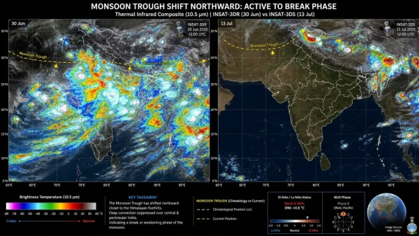
There is an April feel to the Indian sky this July, and two overhead views make plain the reason for it. During what should be the height of the season, the cloud cover has been stripped from the ocean and the main rain belt – a textbook break. The IMD is calling for light rain in central and peninsular India to last until about the 17th.
Put an image from 13 days ago side by side with one from today and the difference is hard to miss. Back on June 30, you could see a wall of cloud over the west, east and centre of the country. Fast forward to July 13 and the deep convection has pulled back from the middle of the map to huddle around the Himalayas and the Northeast.
It is a jarring lull after a rough beginning. June was short some 40 per cent of what was needed, one of the poorest showings in more than a century. As of July 8, the tally was 195.5 mm, or 15.2 per cent under the 230.4 mm average. For the period running from June 1 to mid-July, the nation has been 18% in the hole.
What the satellites are showing
Isro’s INSAT-3DR and 3DS are the eyes on the weather, tracking clouds in both visible and infrared. Infrared is where you spot the cold tops of clouds that are churning up the kind of thunderheads needed for a good, long downpour.
For the first part of July, there were two major systems at work: one in the Arabian Sea putting down on the Konkan and Western Ghats, another in the Bay of Bengal for the east. This week, they have both idled, and the frame is left with very few of the clouds that put out the rain.
You are left with some shallow, pretty formations that do little for the crops. The seas are uncharacteristically open and in central India the sun is out, a scene one would expect in April rather than now.
The monsoon has not given up, it has just moved
The low-pressure trough that typically extends from northwest India to the head of the Bay has inched up to the Himalayan foothills. According to the IMD’s outlook for the 9th to 22nd, the western tip of the trough has been in or above its usual spot for the first week of the month.
One change like that and the whole map is different. Where the core of the country would have seen moisture, it is now being forced into the foothills. An update on July 11 had the IMD flagging off some heavy to very heavy rain in the sub-Himalayan areas of West Bengal and Sikkim, as well as in Bihar and eastern Uttar Pradesh.
The rest of the country is under a kind of atmospheric cap. The air is sinking, which warms and dries it, and any chance of a storm is nipped in the bud. You end up with mugginess but no upward force to make a thunderhead.
Here is the lay of the land for the coming week:
– Northeast, sub-Himalayan West Bengal, Sikkim: heavy to very heavy
– Bihar and east Uttar Pradesh: isolated heavy to very heavy
Central, western, peninsular India: subdued, with clear spells in between
– West coast: less of a show, save for the odd local burst
No rainmakers in sight, and the Arabian Sea is calm
Normally, you can count on the Bay of Bengal to bring in the July showers for central India. A low will form in the warm waters and head for Odisha, Chhattisgarh and Madhya Pradesh, leaving its load of water in its wake.
We saw some of that with the early push this month. A depression put in an appearance on the 5th, made its way through Jharkhand and the like, and brought some extreme rain. There was also an active trough on the west coast to stir things up for a time.
But there is nothing to follow in the wake of that system. With the Bay in a lull, the supply to the interior is done for. The Arabian Sea has let up as well; the jet stream that usually drives wet winds into the Western Ghats has lost some of its oomph, and with it the orographic lifting that makes for a sure bet on rain.
Some global influences at play
There are bigger patterns at work here. The IMD says we are in a weak El Nino and that is not going to change for the duration of the season. The Pacific is warm, so the air is rising there and sinking over places like India, which puts a damper on convection. It is the same story that led to the 40 per cent shortfall in June.
Then you have the Madden-Julian Oscillation, the wave of rain and cloud that makes its way around the equator. It is in phase 8 at the moment, a spot where it is apt to hold back on the Indian side of things. The planet’s rain engine is making noise, but not here.
And the one thing that can sometimes offset an El Nino is not in evidence. A positive Indian Ocean Dipole might have been able to channel in some moisture from the west, but that is not in the cards right now.
With the Dipole in a neutral state this year, there is no local shield to be had. Put these elements in context and they make sense of the April-like satellite data and the lopsided rainfall we have seen in 2026 up to now.
When can we put the rains back on the calendar?
A good opening for a comeback is in view. The IMD’s extended forecast for July 16-22 has the monsoon trough’s western end making its way back to where it should be for a number of days, which is what is required to get the heart of the monsoon zone going again.
But the more telling development is a cyclonic circulation that is set to form over the northwest Bay of Bengal. In its wake, a new low pressure area is due to appear in the first part of the week. Central India is in need of that kind of conduit.
Should the low put down roots and move in, it will draw the trough with it and the moisture will start to flow. The IMD is looking at a return of rain on a broader scale, some of it heavy or very heavy in central India, along the west coast and elsewhere.
Before that happens, though, much of central, western and peninsular India can count on open skies and a hard sun. Temperatures will be on the rise and the humidity will be thick enough to make the feels-like numbers tell a story, rain or no.
For the time being, the wettest conditions are in the east and northeast. Models show 200 to 300 mm of accumulation in most of the northeastern states over the coming week. Meghalaya is in for the brunt of it; in some spots the total could top 500 mm, and if the ground is already sopping, that means a higher chance of flooding and slides.
The country’s tally is still in the red. From June 1 to July 13 the deficit has been whittled down, but we are 18% under normal. It is a sign the monsoon has work to do to even things out.
Breaks in the pattern come and go – two or four in a season is par for the course. This one is a bit more disconcerting given the timing and the numbers. We had a hard entry and now, when the season ought to be in full swing, we have a lull.
The monsoon made its mark in Kerala on June 4 and was all over the map by July 9, a day late at most. But the early July deluge only went so far in making up for what was left wanting in June, and some of the main basins and fields are still dry.
As of July 8, we were 15.2 per cent behind the long-term average of 230.4 mm, with 195.5 mm in the bank. That is a figure to be mindful of in any planning, since you want steady inflows into the catchments, not a few hard showers here and there.
Looking at the monthly, the IMD sees July as sub-normal, coming in under 94 per cent of the 280.4 mm average. The seasonal outlook is in the same vein, so there is no let-up in the pressure for the weeks to come.
In the field, mid-July is a critical time. The Kharif crops – rice, cotton, soybean, maize – that were put in with the first of the rains are at their most demanding stage and cannot be left to a long dry spell.
A week without rain is something you can manage with what is in the soil and some judicious irrigation. Go longer than that and you see reservoir filling and groundwater recharge stall, particularly in the rainfed areas with no other option.
So the issue is not if the break is over, but how firmly the Bay of Bengal will put the rain train back in motion. All eyes will be on system building over the warm water in the northwest.
If the low comes to be, this has been a pause for effect. If not, we may be in for a July to match the fifth-driest June in over a century.
You can see the whole narrative in the INSAT-3DS imagery. A thermal infrared from June 30 would have shown the core monsoon zone awash in cold-topped convection. Fast forward to July 13 and those deep clouds have pulled back from the centre of the country to the Himalayan foothills and the Northeast, a textbook case of the monsoon breaking as the trough heads north.
It is a 13-day about-face that proves how nimbly the monsoon can turn. And it is why having a system form in the Bay at the right moment is so important to even out the distribution.
The satellites are more than just for show. With the 3DR and 3DS, you can follow the ebb and flow of convection in near real time by the cloud-top readings.
What to look for in the coming days:
– A cyclonic circulation in the northwest Bay
– A new low in the first half of the week
– Where the monsoon trough is in relation to the plains
– 200-300 mm in the Northeast
– The odd 500+ mm in parts of Meghalaya
Absent a new system from the Bay to yank the trough south, the rest of the country is going to be left wanting while the Northeast takes the heaviest of the rain. The next seven days will tell us if July is a month of mending or of more of the same.