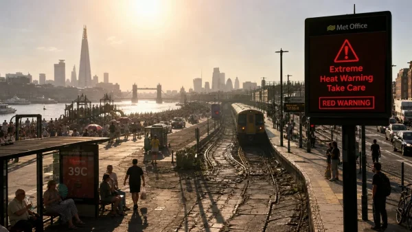
We are in for a bit of a dangerous June. The Met has put out an extreme heat warning for parts of England and Wales – a red one, which you don’t see often – with 38 to 39C in the cards for London and the south on Wednesday and Thursday. There’s also an amber alert in play for four days now, and it means there are some serious hazards to be had in your day-to-day life.
According to the forecasters, the heat is going to ramp up from Monday and be at its worst in the middle of the week. It will be muggy and the nights won’t give you much of a break. This isn’t just another hot few days, officials say. It is a proper weather event that could put a strain on the system and make for some travel headaches.
Where and when temperatures will surge
The south and east of England are where you’ll feel it most. We’re looking at 34C on Monday, then up to 37C on Tuesday. By Wednesday and Thursday, 38C is on the table. In and around London and the south, they are forecasting 38 to 39C for midweek.
Don’t count on any respite after dark. ‘Tropical nights’ are in the offing for much of southern England, with the mercury not dropping below 20C. Even if you aren’t in a red zone, most of the UK will be running well above what you’d normally expect for this time of year.
Records in sight, and a slim chance beyond
This could be a record-setter for June. The current mark is 35.6C, put down in Southampton way back in 1976 and in Camden Square, London in 1957. Some of the models have a small but non-zero probability of us going over 40C, so confidence is building that we might see the old numbers dethroned.
You may even hear about three days in a row over 37C, which is uncharted territory for the month. If it happens, it will be a clear sign of how out of the ordinary this is.
What red and amber alerts mean for you
When you see a red, it’s the top-tier warning: there is a very high risk to life and disruption is all but certain. That’s what is in effect for bits of the south, the Midlands and southern Wales. An amber is in force for a wider area from Monday to Thursday.
To go with the Met’s word, the UK Health Security Agency has put out its own warnings. If you are older, have young ones, or any kind of health issue, you are in a more exposed position. The health service is ready for the pressure to build if the heat doesn’t let up.
How daily life could be hit
Tom Crabtree, the Met’s deputy chief, has no doubt this is an ‘impactful severe weather event’. The combination of the temperature and the humidity is enough to put a load on our transport, energy and water. You may find some rail and road issues as the infrastructure takes the heat.
Power use is set to be up and the local authorities are standing by. And for those making for the coast or a lake to cool off, the water safety types are once again asking for a little care, given the kind of numbers we’ve seen in past heatwaves.
Here is what the advice is to keep you safe:
– Drink up and don’t push yourself in the middle of the day.
– If you don’t have to go out during the peak, don’t.
– Make sure you check in on an elderly neighbour or anyone with a condition.
– Be careful around the water at beaches and rivers.
What comes next
The Met will be keeping a close eye on things as the week goes on. We should see a slight let-up by Friday, but many in England will still be in the low 30s, so the after-effects of the heat could stick around even after the warning is lifted.
Then there is the bigger picture. These kinds of events are only getting more common and more hard-hitting. 2025 was the hottest June we have had, and scientists put that down to climate change. A red warning is still something of an anomaly – the system is only as old as 2021 and we first saw it in action in July 2022.
So for a tough week ahead in England and Wales, the word from the forecasters is plain: get your facts, plan for the hot part of the day and be there for the ones who can least handle it.