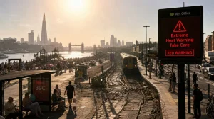
As the holiday weekend approaches, a heatwave alert is in effect for much of the country. The NWS is warning of what could be a once-in-a-lifetime run of extreme weather in the heartland and the East. You can expect the high humidity to ratchet up the danger and keep you from any kind of respite after dark.
What is driving the heat and who is most exposed
If you ask the meteorologists, it’s a ‘heat dome’ that has made a home over a large swath of the country. “The summer pattern has been more stagnant than usual,” said Bryan Putnam with the NWS’s Weather Prediction Center, pointing to the humidity as an amplifier for the kind of heat we’re seeing.
There is a particular concern for the elderly and those with trouble breathing. Health officials will tell you that when the heat lingers through the night, the risks add up; your body doesn’t get the time it needs to recover.
Where and when the worst heat will hit
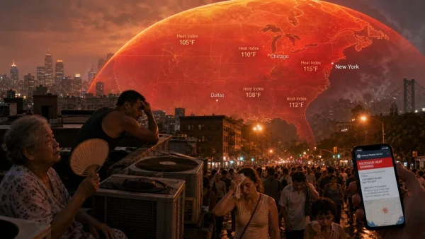
According to the NWS, you can expect some record-breaking numbers in the eastern two-thirds of the nation. We are looking at the lower Great Lakes, the Mid-Atlantic and the valleys of the Mississippi and Ohio rivers right up to the 4th. From there, it will hold into next week in the eastern Plains, the Southeast and the like.
You’ll see big cities getting ready for it. On the East Coast, that means New York, Philadelphia, Washington and Baltimore. In the Midwest and around the lakes, Chicago, St Louis and Detroit are in the mix. Don’t forget some of the South: Dallas, Little Rock and Memphis are in the line of fire as well.
We’ve seen extreme heat warnings put in place for bits of Illinois, Iowa, Kansas, Michigan and Tennessee. Then there are separate advisories for parts of Iowa, Kansas and Missouri – it’s a sign of how far the risk is reaching down the middle of the country.
Complicating weather around the edges
The heat isn’t the only thing to worry about. Out in the Four Corners, you have the makings of some treacherous fire weather. And if you head to the northern Plains or Upper Midwest, there are still some bad thunderstorms to contend with, with the potential for flooding stretching from the Rockies to the Mid-Atlantic.
Then you have the West, which is a different story. It’s been uncharacteristically cool in many places. We’re talking 20 to 35F under normal in the Northwest and the northern Rockies.
Heat metrics to watch
Temperatures are on track for the upper 90s and low 100s (mid- to high-30s C). But with the mugginess in the air, the heat index – or what it actually feels like – is going to be in the 100 to 110F range in some spots.
In a few places, it could be as much as 115F (46C). And since the overnight lows won’t drop below the 70s (21 to 26C), you won’t be able to let your body cool off, which makes being in this for a few days in a row a lot more of a hazard.
The NWS made its case back on 28 June, and for good reason. With the humidity on top of the rising mercury, this week is going to feel like more than the numbers suggest.
According to officials, we’re in for the first of the summer’s broad heatwaves, and it’s set to be felt in over half the nation.
Health risks and what you should know
You don’t have to look far for the numbers: extreme heat is the top weather-related killer in the U.S. every year. As the mercury rises, so does the strain on our hospitals. The NWS has put some areas on an Extreme Heat Risk alert, with a good chunk of the central and eastern U.S. in the moderate to major risk category.
The message from authorities is to play it safe. Don’t be out in the elements if you can help it, drink up, and make sure you have a way to get to an air-conditioned room or a cooling station when it’s at its worst. If you live in one of the hot spots, the NWS is saying you might as well call off any plans to be outside and keep your coolers and A/C running, even after dark.
The CDC has a list of telltale signs that you are overheating: cramps, dizziness, a head full of sweat, trouble breathing, or just feeling weak and queasy. Any of those are a signal to cool down right then and there.
When the day is at its harshest, here is what they are putting forward:
– Cut back on being outside, in the middle of the afternoon in particular
– Water and electrolytes are your friend
– Head to an A/C or a community centre
– Let your system recover by keeping the cold on through the night
Why this is a concern
It’s the timing that makes it tricky. We are heading into 4 July, which means more folks will be out and about for the holiday and to see in the festivities, right when the heat is peaking. That puts you in harm’s way, especially if you don’t have easy access to some relief or if you don’t give enough credit to how the humidity can wear you down.
Then you have the cities. From the East Coast to the Great Lakes, the built-up nature of these places holds onto the heat. With overnight temps not dipping below the 70s, city-dwellers are in for a few days without much of a break, and that is where you see a jump in heat illness.
*
Put in a global context
There is no denying that climate change is making these kinds of events more common and more severe, scientists say. Over in Europe, they are under a heat dome of their own; Germany hit 106 on June 27. France has had to deal with a string of drownings this month as people tried to find some respite in the water.
We’ve had our share of oddball weather in the U.S., too. Back in March, an unseasonal wave of heat took some of the West to 108F. But what we are seeing now is different in its scope and the fact that it is happening during a time when everyone is out.
What to expect**
The NWS is calling for the heat to hold on through 4 July in the lower Great Lakes, the Mid-Atlantic and the river valleys of the Mississippi and Ohio. And it won’t let up next week in parts of the eastern Plains, the Southeast and the like.
It will be most of an issue in the big cities on the East Coast – New York, Philly, D.C., Baltimore – and in the Midwest and around the lakes, like Chicago, St. Louis and Detroit. You’ll see some of it in the South in places like Dallas and Memphis.
The NWS doesn’t mince words: we are in for some record-setting conditions. Their advice is as straightforward as it gets. Stay in, put some water in you, and make sure you are in a cool place, day and night.